Geographic Areas: Difference between revisions
imported>Arkalor No edit summary |
imported>An Adventurer m (removing some styling that made text hard to read) |
||
| (7 intermediate revisions by one other user not shown) | |||
| Line 1: | Line 1: | ||
{{Related| | {{Related|Locations}} | ||
{{Links Header|[[Geographic Areas]] - [[Spawn Distributions]]}} | {{Links Header|[[Geographic Areas]] - [[Spawn Distributions]]}} | ||
{{righttoc}} | |||
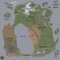
Asheron's Call has been updated or "patched" on a monthly basis from its launch in the fall of 1999. Occasionally large content additions are made in the form of new islands, such as Aphus Lassel and Aerlinthe. Other times an area is repurposed, such as Graveyard and Valley of Death. AC has had two expansions that also introduced new regions. Dark Majesty brought Marae Lassel and Throne of Destiny brought the Halaetan Isles. Below is a listing of the geographic regions and areas that have been added, expanded, or are explicitly referred to in game. | Asheron's Call has been updated or "patched" on a monthly basis from its launch in the fall of 1999. Occasionally large content additions are made in the form of new islands, such as Aphus Lassel and Aerlinthe. Other times an area is repurposed, such as Graveyard and Valley of Death. AC has had two expansions that also introduced new regions. Dark Majesty brought Marae Lassel and Throne of Destiny brought the Halaetan Isles. Below is a listing of the geographic regions and areas that have been added, expanded, or are explicitly referred to in game. | ||
{|cellpadding=5 | |||
The game world is over 500 square miles (1,300 km²) in size.<ref>[[Microsoft Zone Archive/What Is Asheron's Call?]]</ref> | |||
{|cellpadding=5 align=center | |||
| | | | ||
{{Map Point Plus | {{Map Point Plus | ||
| Line 20: | Line 21: | ||
{{MPP Loc | 28.2 | S | 22.8 | W | Large | Inner Sea }} | {{MPP Loc | 28.2 | S | 22.8 | W | Large | Inner Sea }} | ||
{{MPP Loc | 88.5 | N | 46.2 | E | | {{MPP Loc | 88.5 | N | 46.2 | E | Blue | Aerlinthe }} | ||
{{MPP Loc | 92.3 | N | 56.5 | E | | {{MPP Loc | 92.3 | N | 56.5 | E | Blue | Dark Isle }} | ||
{{MPP Loc | 79.0 | N | 65.0 | E | | {{MPP Loc | 79.0 | N | 65.0 | E | Blue | Vissidal }} | ||
{{MPP Loc | 87.4 | N | 62.0 | W | | {{MPP Loc | 87.4 | N | 62.0 | W | Blue | Halaetan Isles }} | ||
{{MPP Loc | 49.0 | N | 78.0 | W | | {{MPP Loc | 49.0 | N | 78.0 | W | Blue | Marae Lassel }} | ||
{{MPP Loc | 20.1 | N | 70.5 | E | | {{MPP Loc | 20.1 | N | 70.5 | E | Blue | Asheron's Island }} | ||
{{MPP Loc | 92.5 | S | 53.0 | W | | {{MPP Loc | 92.5 | S | 53.0 | W | Blue | Moarsman Island }} | ||
{{MPP Loc | 4.2 | S | 91.5 | E | | {{MPP Loc | 4.2 | S | 91.5 | E | Blue | Aphus Lassel }} | ||
{{MPP Loc | 94.7 | S | 94.9 | W | | {{MPP Loc | 94.7 | S | 94.9 | W | Blue | Singularity Caul }} | ||
{{MPP Loc | 94.8 | S | 9.7 | W | | {{MPP Loc | 94.8 | S | 9.7 | W | Blue | Ulgrim's Island }} | ||
{{MPP Loc | 21.3 | N | 53.9 | E | | {{MPP Loc | 21.3 | N | 53.9 | E | Blue | Isle of Tears }} | ||
{{MPP Loc | 17.4 | N | 51.1 | W | | {{MPP Loc | 17.4 | N | 51.1 | W | Blue | Northern Landbridge }} | ||
{{MPP Loc | 85.0 | S | 13.2 | W | | {{MPP Loc | 85.0 | S | 13.2 | W | Blue | Southern Landbridge }} | ||
{{MPP Loc | 37.7 | N | 1.3 | W | | {{MPP Loc | 37.7 | N | 1.3 | W | Blue | Tiofor Woods }} | ||
{{MPP Loc | 52.0 | N | 46.8 | E | | {{MPP Loc | 52.0 | N | 46.8 | E | Blue | Lost Wish Mountain Range }} | ||
{{MPP Loc | 57.8 | N | 62.0 | E | | {{MPP Loc | 57.8 | N | 62.0 | E | Blue | Olthoi North }} | ||
{{MPP Loc | 65.8 | N | 81.0 | E | | {{MPP Loc | 65.8 | N | 81.0 | E | Blue | Olthoi Island }} | ||
{{MPP Loc | 74.2 | N | 7.2 | W | | {{MPP Loc | 74.2 | N | 7.2 | W | Blue | Esper Mountain Range }} | ||
{{MPP Loc | 76.0 | S | 42.0 | E | | {{MPP Loc | 76.0 | S | 42.0 | E | Blue | Linvak Mountain Range }} | ||
{{MPP Loc | 66.0 | N | 24.7 | W | | {{MPP Loc | 66.0 | N | 24.7 | W | Blue | Stonehold Valley }} | ||
{{MPP Loc | 9.0 | N | 40.0 | E | | {{MPP Loc | 9.0 | N | 40.0 | E | Blue | Plains of Gaerwel }} | ||
{{MPP Loc | 26.0 | S | 11.1 | E | | {{MPP Loc | 26.0 | S | 11.1 | E | Blue | A'mun Desert }} | ||
{{MPP Loc | 12.2 | S | 19.1 | E | | {{MPP Loc | 12.2 | S | 19.1 | E | Blue | Yushad Ridge }} | ||
{{MPP Loc | 3.4 | N | 28.3 | E | | {{MPP Loc | 17.0 | N | 16.0 | E | Blue | Mount Alphus Range }} | ||
{{MPP Loc | 21.5 | S | 1.6 | W | | {{MPP Loc | 3.4 | N | 28.3 | E | Blue | Falamar Hills }} | ||
{{MPP Loc | 25.4 | S | 52.3 | E | | {{MPP Loc | 21.5 | S | 1.6 | W | Blue | Yaraq Cove }} | ||
{{MPP Loc | 45.0 | S | 55.0 | E | | {{MPP Loc | 25.4 | S | 52.3 | E | Blue | Blackmire Swamp }} | ||
{{MPP Loc | 75.4 | S | 91.1 | E | | {{MPP Loc | 45.0 | S | 55.0 | E | Blue | Snowflake Mountain Range }} | ||
{{MPP Loc | 76.5 | S | 45.1 | W | | {{MPP Loc | 35.5 | S | 93.4 | E | Blue | Tou-Tou Peninsula }} | ||
{{MPP Loc | 85.5 | S | 65.0 | W | | {{MPP Loc | 75.4 | S | 91.1 | E | Blue | Vesayen Isles }} | ||
{{MPP Loc | 80.4 | S | 75.5 | W | | {{MPP Loc | 76.5 | S | 45.1 | W | Blue | South Direlands Craters }} | ||
{{MPP Loc | 52.3 | S | 73.4 | W | | {{MPP Loc | 85.5 | S | 65.0 | W | Blue | Direlands Midlands }} | ||
{{MPP Loc | 36.0 | S | 64.4 | W | | {{MPP Loc | 80.4 | S | 75.5 | W | Blue | Withered Atoll }} | ||
{{MPP Loc | 44.6 | S | 51.0 | W | | {{MPP Loc | 52.3 | S | 73.4 | W | Blue | Black Hills }} | ||
{{MPP Loc | 60.0 | S | 63.0 | W | | {{MPP Loc | 36.0 | S | 64.4 | W | Blue | Valley of Death }} | ||
{{MPP Loc | 44.6 | S | 51.0 | W | Blue | East Direlands Swamp }} | |||
{{MPP Loc | 60.0 | S | 63.0 | W | Blue | Obsidian Plains }} | |||
{{MPP Loc | 10.4 | S | 75.2 | W | | {{MPP Loc | 10.4 | S | 75.2 | W | Yellow | Direlands Gear Knight Invasion Area }} | ||
{{MPP Loc | 83.3 | N | 5.3 | W | | {{MPP Loc | 83.3 | N | 5.3 | W | Yellow | Frozen Valley }} | ||
{{MPP Loc | 65.4 | S | 44.0 | W | | {{MPP Loc | 65.4 | S | 44.0 | W | Yellow | Graveyard }} | ||
{{MPP Loc | 21.1 | S | 5.3 | E | | {{MPP Loc | 21.1 | S | 5.3 | E | Yellow | City of Neftet }} | ||
{{MPP Loc | 28.1 | S | 95.9 | E | Yellow | Tou-Tou }} | |||
{{MPP Loc | 78.1 | N | 48.2 | W | Yellow | Hoshino's Fortress }} | |||
}} | }} | ||
'' | {|width=100% | ||
<br> [[File:Map Point Large.png]] | | | ||
<br> [[File:Map Point | ''Hover over a location on the map to view its name, or click to view its information page.'' | ||
<br> [[File:Map Point | <br>[[File:Map Point Large.png]] Main geographic areas | ||
<br> [[File:Map Point Blue.png]] Regions and islands of Dereth | |||
<br> [[File:Map Point Yellow.png]] High level hunting grounds | |||
|} | |||
|} | |} | ||
| Line 73: | Line 79: | ||
* [[Inner Sea]] | * [[Inner Sea]] | ||
== Mainland Dereth == | |||
=== [[Osteth]] === | |||
* [[Northern Osteth]] | * [[Northern Osteth]] | ||
** [[Esper Mountain Range]] | ** [[Esper Mountain Range]] | ||
| Line 92: | Line 97: | ||
** [[Yushad Ridge]] | ** [[Yushad Ridge]] | ||
** [[Snowflake Mountain Range]] | ** [[Snowflake Mountain Range]] | ||
** Tou-Tou Peninsula | |||
*** [[Tou-Tou]] | |||
** [[River Prosper|Middle River Proper and Lake Blessed]] | ** [[River Prosper|Middle River Proper and Lake Blessed]] | ||
*** [[Isle of Tears]] | *** [[Isle of Tears]] | ||
| Line 98: | Line 105: | ||
** [[Southern Landbridge]] | ** [[Southern Landbridge]] | ||
=== [[Direlands]] === | |||
* [[North Direlands]] | * [[North Direlands]] | ||
** [[Crystalline Crag]] | ** [[Crystalline Crag]] | ||
| Line 116: | Line 123: | ||
** [[Withered Atoll]] | ** [[Withered Atoll]] | ||
=== Landbridges === | |||
* [[Northern Landbridge]] | * [[Northern Landbridge]] | ||
* [[Southern Landbridge]] | * [[Southern Landbridge]] | ||
== Islands of Dereth == | |||
=== [[Aerlinthe|Aerlinthe Island]] === | |||
* [[Tenkarrdun]] | * [[Tenkarrdun]] | ||
=== [[Aphus Lassel]] === | |||
=== [[Asheron's Island]] === | |||
* [[Asheron's Castle]] | * [[Asheron's Castle]] | ||
=== [[Dark Isle]] === | |||
=== [[Halaetan Isles]] === | |||
* [[Corcima Castle]] | * [[Corcima Castle]] | ||
* [[Corcosi Island]] | * [[Corcosi Island]] | ||
| Line 141: | Line 147: | ||
* [[Vanguard Isle]] | * [[Vanguard Isle]] | ||
=== [[Marae Lassel]] === | |||
* [[Ahurenga Plains]] | * [[Ahurenga Plains]] | ||
* [[Karab Delta]] | * [[Karab Delta]] | ||
| Line 148: | Line 154: | ||
* [[Tuatara Plains]] | * [[Tuatara Plains]] | ||
=== [[Moarsman Island]] === | |||
=== [[Olthoi Island]] === | |||
=== [[Singularity Caul]] === | |||
* [[North Singularity Caul]] | * [[North Singularity Caul]] | ||
* [[West Singularity Caul]] | * [[West Singularity Caul]] | ||
| Line 159: | Line 165: | ||
* [[Caulcano]] | * [[Caulcano]] | ||
=== [[Ulgrim's Island]] === | |||
=== [[Vesayen Isles]] === | |||
* [[Avalelle Island]] | * [[Avalelle Island]] | ||
* [[Ithaenc Island]] | * [[Ithaenc Island]] | ||
| Line 172: | Line 178: | ||
* [[Freebooter Isle]] | * [[Freebooter Isle]] | ||
=== [[Vissidal|Vissidal Island]] === | |||
== Offworld == | |||
=== [[Bur]] === | |||
* [[Kor-Gursha]] | * [[Kor-Gursha]] | ||
== Images == | |||
<gallery widths=200px heights=200px perrow=3> | <gallery widths=200px heights=200px perrow=3> | ||
File:Map of Dereth.jpg|Map of Dereth | File:Map of Dereth.jpg|Map of Dereth | ||
</gallery> | </gallery> | ||
[[Category:Geographic | == References == | ||
<references/> | |||
[[Category:Geographic Areas]] | |||
Latest revision as of 14:14, 22 September 2020
Related topics: Locations
Asheron's Call has been updated or "patched" on a monthly basis from its launch in the fall of 1999. Occasionally large content additions are made in the form of new islands, such as Aphus Lassel and Aerlinthe. Other times an area is repurposed, such as Graveyard and Valley of Death. AC has had two expansions that also introduced new regions. Dark Majesty brought Marae Lassel and Throne of Destiny brought the Halaetan Isles. Below is a listing of the geographic regions and areas that have been added, expanded, or are explicitly referred to in game.
The game world is over 500 square miles (1,300 km²) in size.[1]
|
|


Mainland Dereth
Osteth
Direlands
Landbridges
Islands of Dereth
Aerlinthe Island
Aphus Lassel
Asheron's Island
Dark Isle
Halaetan Isles
- Corcima Castle
- Corcosi Island
- Count Dardante's Island
- Isle of Ruin
- Lotila Island
- Traitor's Island
- Vanguard Isle
Marae Lassel
Moarsman Island
Olthoi Island
Singularity Caul
Ulgrim's Island
Vesayen Isles
- Avalelle Island
- Ithaenc Island
- Laesvos Island
- MacNiall's Island
- Miremdae Island
- Savao Island
- Thesalene Island
- Xi Ru's Island
- Freebooter Isle
Vissidal Island
Offworld
Bur
Images
-
Map of Dereth
